


NMCAMT
Lists
the number of real-time grids received for a specified day.
Format
NMCAMT [keywords]
Keywords
DAY= |
Julian
day, YYDDD (default=current) |
FORM= |
STD |
lists
a brief description of the grids; see the Remarks (default) |
|
ALL |
lists
detailed information about the grids; see the Remarks |
GRIDF= |
grid
file numbers to check (default=lists all real-time grid files for the
specified day) |
MOD= |
ALL |
searches
all model types (default) |
|
m1
. . mn |
searches
for one or more specific models, valid options are: |
|
GFS |
Global
Forecast System model grids |
|
NAM |
North
American Mesoscale model grids |
|
NGM |
Nested
Grid Model grids |
TIME= |
ALL |
searches
all run times (default) |
|
t1
. . tn |
searches
the specified range of run times, H, HH:MM or HH:MM:SS |
Remarks
NMCAMT lists
both complete and partial real-time grids. A partial grid contains incomplete
grid sections. Currently, the Medium Range Forecast (MRF) model is the only
model transmitted in pieces; thus, it is the only model containing partial
grids.
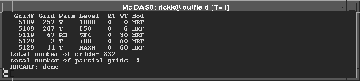
The FORM=STD
option provides the following information:
- grid file
number
- grid number
- parameter
- level
- run time
- forecast
time
- model
name of partial grids
The screen
below shows an example of the FORM=STD output.
The projection
of an GFS grid determines how it is sent. Grids that are 145 rows by 289 columns
are sent in the following eight sectors:
| Sector |
Latitude
range |
Longitude
range |
1 |
0°N-90°N |
60°E-30W |
2 |
0°N-90°N |
150°E-60°E |
3 |
0°N-90°N |
120°W-150°E |
4 |
0°N-90°N |
30°W-120°W |
5 |
0°S-90°S |
60°E-30°W |
6 |
0°S-90°S |
150°E-60°E |
7 |
0°S-90°S |
120°W-150°E |
8 |
0°S-90°S |
30°W-120°W |
Grids that
are 73 rows by 73 columns are sent in the following four sectors:
| Sector |
Latitude
range |
Longitude
range |
1 |
0°N-90°N |
180°E-0°E |
2 |
0°N-90°N |
0°W-180°W |
3 |
0°S-90°S |
180°E-0°E |
4 |
0°S-90°S |
0°W-180°W |
If a grid
is missing a section, the FORM=ALL option marks the missing section with an
asterisk (*). In the example below, grid 257 in grid file 5109 is missing the
fourth section. The Xs indicate that sectors 1-3 and 5-8 were received.
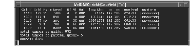
The FORM=ALL
option provides the following additional information:
- byte location
of the message in the spool file
- the number
of rows and columns of the grid
- the time
the grid was received
Examples
NMCAMT
This entry
lists all the real-time grids that are missing grid sections and the total
number of grids received for the current day.
NMCAMT
MOD=GFS FORM=ALL TIME=0
This entry
lists, in expanded form, all the 0 UTC model run GFS grids.