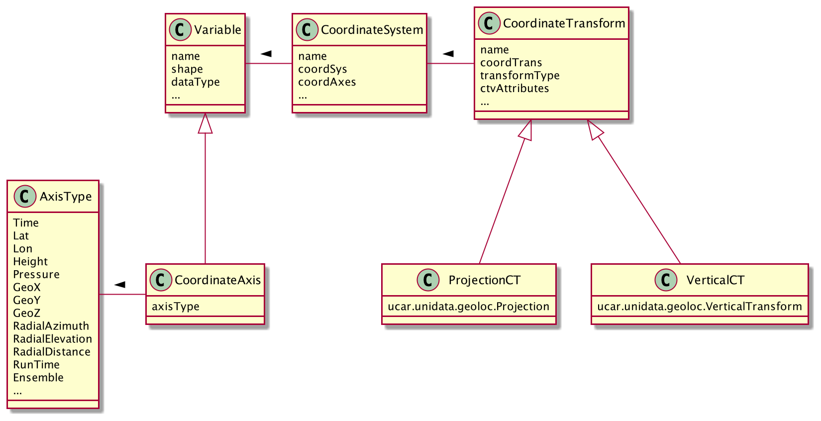
Overview of coordinate attribute convention
For a brief overview, see: CDM Object Model. The CoordinateAxis for a Variable must use a subset of the Variable’s dimensions.
Goals of _Coordinate Attribute Convention
- Encode coordinate system information into both netcdf-3 and netcdf-4 files.
- Easily retrofit existing files with coordinate info using NcML.
- Use the existing “Coordinate variable” convention to infer
CoordinateSystemsfor legacy files - Allow minimum annotation to existing datasets to fully specify
CoordinateSystemsandCoordinateTransforms
Proposal
- Add the following “standard attributes” as an endorsed way of encoding coordinate system information.
- Create an API in both C and Java libraries to make it easy for users to follow these standards. The APIs will be optional, and built on top of the core APIs.
- Use the attributes and APIs in Unidata software when appropriate.
See also :
_Coordinate Attribute Examples
Contents
- Summary of the CDM _Coordinate Conventions
- Coordinate Attributes Definition
- Summary of Rules for Processing Coordinate Attributes
Summary of the CDM _Coordinate Conventions:
A CoordinateTransform is defined by creating a CoordinateTransform variable example and reference.
The attributes of the CoordinateTransform variable become the parameters of the transform. A variable is a CoordinateTransform variable if one (or both) of these is true:
- It has a
_CoordinateTransformTypeor_CoordinateAxisTypesattribute. - It is listed in a
_CoordinateTransformsattribute from any variable in the file.
Any Variable can be a CoordinateTransform variable, as it is just a container for attributes, i.e. the data values of the Variable are not used by the transform.
It is common to use a vertical coordinate to be a CoordinateTransform variable. Using a dummy variable (with no useful data in it) is also common. The examples here are done with dummy variables.
The CF CoordSystemBuilder will add the _CoordinateTransformType attribute upon recognizing a standard name, so adding that is optional if you are using CF conventions.
CF also requires that you use the vertical coordinate as the CoordinateTransform variable, so that the transform will be added to any CoordinateSystem that uses that vertical coordinate.
The CF CoordSystemBuilder will thus add the _CoordinateAxes = "vertCoordName" attribute to indicate this.
Coordinate Attributes Definition
_CoordinateAliasForDimension
A one-dimensional variable with monotonic values can act as a Coordinate variable for its dimension, even when it doesn’t have the same name as the dimension.
To indicate this, add an attribute to the variable called _CoordinateAliasForDimension, whose value must be the name of its single dimension.
A dimension may have multiple Coordinate variables in this way, for example if the data is a trajectory.
   double valtime(record);
     :long_name = "valid time";
     :units = "hours since 1992-1-1";

  :_CoordinateAliasForDimension = "record";
     :_CoordinateAxisType = "Time";
_CoordinateAxes
This attribute lists (in any order) names of CoordinateAxis variables. When a Variable is listed in a _CoordinateAxes attribute, it is made into a CoordinateAxis.
The attribute value must be a space-separated list of names of CoordinateAxis variables in the same dataset:
_CoordinateAxes = "time lev lat lon";
_CoordinateAxisType
This attribute is used on a CoordinateAxis variable to specify that it is a space or time coordinate, such as lat, lon, altitude or time.
Currently the valid values are Lat, Lon, Height, Pressure, Time, GeoX, GeoY, GeoZ, RadialElevation, RadialAzimuth, or RadialDistance.
This is the preferred way to make a Variable into a CoordinateAxis (the other way is to list the variable in a _CoordinateAxes attribute).
The attribute value must be one of the valid AxisTypes, for example:
_CoordinateAxisType = "Lat";
_CoordinateAxisTypes
This attribute is used on a CoordinateTransform variable to specify that the transform applies to any CoordinateSystem with the specified list of AxisTypes.
The attribute value must be a list of the valid AxisTypes (see ucar.nc2.constants.AxisType):
_CoordinateAxisTypes = "GeoZ Time";
_CoordinateSystems
When many data variables use the same CoordinateSystem it is convenient to factor out the information into one place.
We create a dummy variable which holds all of the information, called the CoordinateSystem variable.
The CoordinateSystems attribute is used on a data variable to point to its CoordinateSystem variable(s).
This is the only way to indicate multiple CoordinateSystems for the same data variable.
The attribute value must be a space-separated list of names of CoordinateSystem variables in the same dataset:
 _CoordinateSystems = "ProjectionCoordinateSystem LatLonCoordinateSystem";

  char ProjectionCoordinateSystem;
  ProjectionCoordinateSystem:_CoordinateAxes = "time depth_below_surface y x";
  ProjectionCoordinateSystem:_CoordinateTransforms = "Lambert_Conformal_Projection";
_CoordinateSystemFor
This is a way to assign explicit CoordinateSystems to a set of variables, without having to name each variable.
The value of the attribute is a list of dimensions.
A data variable that does not have an explicit _CoordinateSystem or CoordinateAxes attribute will be assigned this CoordinateSystem, if it contains exactly the listed dimensions.
  <variable name="coordSysVar4D" type="int" shape="">
  <attribute name="_CoordinateAxes" value="x y zpos time"/>
  <attribute name="_CoordinateTransforms" value="zpos"/>
  <attribute name="_CoordinateSystemFor" value="xpos ypos zpos time"/>
  </variable>
  <variable name="coordSysVar3D" type="int" shape="">
  <attribute name="_CoordinateAxes" value="x y time"/>
  <attribute name="_CoordinateSystemFor" value="xpos ypos time"/>
  </variable>
_CoordinateTransforms
The _CoordinateTransforms attribute is used only on CoordinateSystem variables and is used to indicate how to transform the CoordinateSystem to a reference CoordinateSystem.
A reference CoordinateSystem is one that uses Latitude, Longitude for the horizontal axes, and Height or Pressure for the vertical axes.
To hold the transform information, create a dummy variable called the CoordinateTransform variable.
This CoordinateTransform variable always has a name that identifies the transform, and any attributes needed for the transformation.
The attribute value must be a space-separated list of names of CoordinateTransform variables in the same dataset.
 _CoordinateTransforms = "LambertProjection HybridSigmaVerticalTransform";

 char LambertProjection;
 LambertProjection:transform_name = "lambert_conformal_conic";
 LambertProjection:standard_parallel = 25.0;

 LambertProjection:longitude_of_central_meridian = 265.0;
 LambertProjection:latitude_of_projection_origin = 25.0;
This is a general mechanism for any transformation a file writer wants to define. The nj22 library has a set of transforms that it recognizes, mostly based on the CF-1 conventions. Attributes should be String, integer, or double valued.
_CoordinateTransformType
This attribute is used to unambiguously indicate that a variable is a CoordinateTransform variable (the other way is to list the variable in a _CoordinateTransforms attribute).
The attribute value must be one of the valid Transform types (see ucar.nc2.dataset.TransformType). Currently the valid values are Projection or Vertical.
_CoordinateTransformType = "Projection";
_CoordinateZisPositive
Only used for vertical coordinate axes to disambiguate direction up or down of increasing coordinate values.
The attribute value must equal “up” or “down”.
_CoordinateZisPositive = "down";
Summary of Rules for Processing Coordinate Attributes
CoordinateAxis Variable
May have attributes:
_CoordinateAxisType_CoordinateAliasForDimension_CoordinateZisPositive
A Variable is made into a CoordinateAxis if one of these is true:
- It has any of the
_CoordinateAxisType,_CoordinateAliasForDimension, or_CoordinateZisPositiveattributes. - It is a
Coordinatevariable - It is listed in a
_CoordinateAxesattribute from any variable in the file.
A Variable is a Coordinate variable if it is one dimensional and one of these is true:
- It has the same name as its dimension.
- It has the
_CoordinateAliasForDimensionattribute.
CoordinateSystem Variable
May have attributes:
_CoordinateAxes(required, must be a complete list of axes, must have at least one axis)._CoordinateSystemFor(list of dimensions) will be assigned to any variable which contains exactly these dimensions._CoordinateTransforms
A variable is a CoordinateSystem variable if one of these is true:
- It has a
_CoordinateTransformsattribute. - Its has a
_CoordinateSystemForattribute. - It is listed in a
_CoordinateSystemsattribute from any variable in the file.
CoordinateTransform Variable
May have attributes:
_CoordinateTransformType_CoordinateSystemsapply to theseCoordinateSystems_CoordinateAxesapply to anyCoordinateSystemsthat contain all these axes_CoordinateAxisTypesapply to anyCoordinateSystemsthat contain all these types of axes
A variable is a CoordinateTransform variable if one of these is true:
- It has a
_CoordinateTransformTypeor_CoordinateAxisTypesattribute. - It is listed in a
_CoordinateTransformsattribute from any variable in the file.
Data Variables
May have attributes:
_CoordinateSystems_CoordinateAxes
You should use one or the other. If both are present, _CoordinateSystems is used.
A data variable is assigned one or more CoordinateSystems in the following way:
- If it has a
_CoordinateSystemsattribute, it is assigned the listedCoordinateSystems, and no further processing is done. - If it has a
_CoordinateAxesattribute, it will have oneCoordinateSystemconsisting of the listed_CoordinateAxesplus anyCoordinatevariables that it uses which are not listed. It must have at least 2 axes, otherwise it will have oneCoordinateSystemconsisting of theCoordinatevariables that it uses.
If CoordSysBuilder.useMaximalCoordSys is true (default is true), and all the following conditions are true:
- A Data Variable has none or one implicit
CoordinateSystem. - Its implicit
CoordinateSystem(if it exists) has fewer axes than the rank of theVariable. Then allCoordinateAxesare examined, and aCoordinateSystemis made out of all that fit theVariable. - If this
CoordinateSystemhas 2 or more axes, then it is assigned to theVariable. This is called the maximal algorithm.
Notes
- Data Variable
CoordinateAxesmay be partial listing, thusCoordinatevariables will be added. - Variables of type
Structurecannot be aCoordinateAxes. - A
CoordinateSystemis defined by its list ofCoordinateAxes, so twoCoordinateSystemscan’t have the same list of axes. _Coordinateattributes will take precedence over conventions in our own decoding. Other software may implement differently.- When
CoordinateSystemshave been added, to prevent adding them again, NcML writing adds the global attribute:Conventions = "_Coordinates".
Coordinate Axis Types
(see ucar.nc2.constants.AxisType)
| AxisType | description | order |
|---|---|---|
| RunTime | model run time | 0 |
| Ensemble | model ensemble | 1 |
| Time | valid time | 2 |
| GeoZ | vertical coordinate | 3 |
| Height | vertical height, convertible to meters | 3 |
| Pressure | vertical pressure, converrtible to hPa | 3 |
| GeoY | projection y coordinate | 4 |
| Lat | geodesic latitude | 4 |
| GeoX | projection x coordinate | 5 |
| Lon | geodesic longitude | 5 |
| RadialAzimuth | polar azimuth | 6 |
| RadialDistance | polar distance | 7 |
| RadialElevation | polar elevation | 8 |