/GeoJson Control")


To use the pre-defined Background images simply select
the Display->Special->Background Image menu item.
To choose imagery from other web map servers
bring up the Data Source Chooser,
go to the Catalogs tab and enter the url that points to
the Capabilities document of the desired WMS.
We also provide links to a set of useful WMSs from the
idvcatalog. If it is not in the Catalog pull down menu
simply enter the url:
https://resources.unidata.ucar.edu/georesources/idvcatalog.xmlFrom this catalog open the Web Map Servers tab and select the WMS you would like to access.
The WMS Control makes request to the Web Map Server for an image that covers the area currently being displayed in the main display. Due to the time it takes to access remote servers the WMS Control does not request new images when the user pans and zooms.
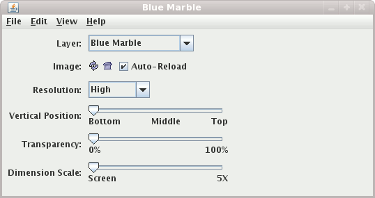
If multiple layers have been selected (using control-click in the WMS Chooser or in the Background Image control) you can choose which layer to view with this menu.
You can reload the image from the server at the current screen location and scale and set the projection in the display to the current image bounds.
When the Auto-Reload button is selected, the
WMS control will automatically fetch a new image every time the main display is panned or zoomed.
There is a slight delay so
that successive zooms do not cause successive image requests.
The Resolution menu allows you to make requests for lower
resolution images. This results in a smaller image file size and
quicker requests from the server.
This slider allows you to set the vertical position of the image.
You can adjust the overall transparency of the image. Note: Some Web Map Servers provide images that contain transparent sections. Currently, the IDV does not support the display of transparent sections.
By default the bounds of the image that is retrieved from the server is the size of the display. This slider allows you to fetch an even larger image.
This is available under the File->Save menu. It takes the most
recently displayed image and writes it out (e.g., as a jpeg file)
and also writes out the IDV's ximg xml file that contains
the reference to the image file and the lat/lon position of the image.
This allows the user to load this image back in without being connected to the original web map server.
If a .kml or .kmz file suffix is given then the Google Earth file is created and the image can be loaded into Google Earth.