Unidata IDV Workshop for version 6.3 > Accessing and Displaying Data > Displaying Satellite and Level III Radar Imagery
3.3.4 Time Matching Radar and Satellite imagery
You can use time matching feature in the IDV to create a time synchronized display with both
radar and satellite imagery.
First, load up a couple of satellite images.
- If other displays and data are already loaded, select the
menu item
or the
icon in the toolbar to clear them out.
- Open the
Data Choosers
.
Click on the Images
node in the chooser tree.
- Choose
adde.ucar.edu
server and
CCS039
dataset, click the Connect
button.
- From the
Image Type:
selector, choose
the 1 km GOES-8 Visible
type.
- Select
the 2 images at 1998-06-29 21:15:00Z
and 1998-06-29 22:15:00Z
.
- Click the
Add Source
button.
- In the
Times
panel, select
the Set As Time Driver
menu item.
- Click the
Create Display
button
to load in those two images.
Next, let's select some radar imagery using the driver times from the satellite imagery.
- First, let's keep the satellite projection for now. Uncheck
the menu item.
- Open the Level III Data Source Chooser
- Open the
Data Choosers
.
- In the
Data Source Chooser
click on the
Radar
tab. Then click on the NEXRAD Remote
tab to see the
Level III radar data remote chooser panel.
- In the catalog selector drop-down, select the motherlode
catalog that is included.
If it is not in the list, type it into the catalog selector area and press enter.
In the collections drop-down, select
Level III Radar for Case Study CCS039
- Zoom in the map and select the station DVN.
- Click on the
Match Time Driver
button on the bottom left.
- Click the
Add Source
button.
- Select the
Reflectivity
field and create a
Radar Sweep View in 2D
display.
- Let's check the time matching result by bring up the animation timeline:
click on , and compare the time selection from two difference
data source.
- Remove all displays and data.
![](images/TimeMatchingTimeLine.png)
Try the following time matching exercises on your own using the real time satellite and radar data.
- First, load in the latest 5 GOES East/West IR Composite and set the Satellite imagery as time driver.
- Second, find the location of interesting weather.
- Then, load in the a few level III radar stations which are close to the area identified in the second step,
and check on the
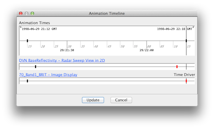
Match Time Driver
button.
- Check the for the matching result.
- Remove all displays and data.
Unidata IDV Workshop for version 6.3 > Accessing and Displaying Data > Displaying Satellite and Level III Radar Imagery