

Unidata IDV Workshop for version 7.0u1 > Accessing and Displaying Data > Point Observations

3.7.3 Layout Model Editor
The
Layout Model Editor allows you to view, change and create
Layout Models.
- First, load in the layout model example from the menu.
- Open up the
Layout Model Editor from the menu.
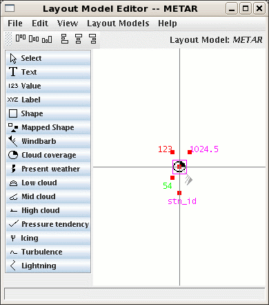
- You should see something like this:
- The
Layout Model Editor consists of:
- A drawing canvas.
- A list of symbols.
-
Select Is an editing command. Puts the editor into
select mode.
-
Text Displays text. Used for station identifiers,
text results from Jython, etc.
-
Value Displays a numeric value. Lets you specify a
display unit and a format.
-
Label Shows a fixed text label.
-
Shape Shows a shape.
-
Mapped Shape Maps a value to a shape.
-
Windbarb Shows wind direction and speed.
-
Cloud coverage, Present weather,
Low cloud, etc.
These symbols are used to map a value into a predefined range of
display
symbols.
- An alignment toolbar.
- , , , and menus.
- Let's go look at the
METAR layout model.
- Right click on the symbol in the upper left that represents temperature and select
- Change some of the properties (e.g., scale, background color, format) and click
Apply.
- The
Apply and OK buttons save your changes to the layout model in the editor.
- The
Save button saves the changes plus writes out the layout model and updates the display.
- Close the dialog and use the menu to get rid of your local changes. Re-select the
METAR
layout model with the menu.
- Try moving some the position of the symbols around. To apply the change to the display
use the menu item.
- Look at the
Earthquake layout model. View the properties for the symbol.
- Create a new Layout Model, called "Workshop".
- Select the menu item.
- In the dialog box enter the name of the new layout model,
"Workshop".
- Click the
OK button.
- Add a symbol.
- Select the
Text symbol in the symbol list.
- Click in the center of the drawing canvas.
- In the
Properties dialog you can select what parameter from
the data
set is used and other display information.
- The value in the
Parameter field should be
"IDN", the WMO Station ID.
- Select Courier in the menu.
- Select an 11 point font in the menu.
- Click the
OK button.
- Position the symbol.
- Click and drag the symbol to the center of the screen.
- Note the red dot on the symbol. This is the Alignment point. It
determines the point on the bounding box of the symbol that is used
to align the symbol with the center point of the display
coordinate space.
- Right click on the symbol to bring up the
- Select the menu item. This should change
the red dot
on the symbol to the upper left corner.
- Right click on the symbol again, but this time select the
menu item.
This aligns the symbol's alignment point to the center of the display
space.
- Save this layout model with the menu item.
- Close the window by selecting the menu item.
- Back to the
Point Data Display, choose the Workshop layout model.
Humm, why isn't anything displayed?


Unidata IDV Workshop for version 7.0u1 > Accessing and Displaying Data > Point Observations


