


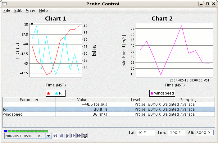
The table shows the parameters with their values, the level at which the value is sampled, and the type of sampling. The location of the probe is shown, in latitude, longitude, and altitude. When surface data is probed the height of the probe point does not matter.
You can add new parameters a number of ways:
Add Parameter...
Edit->Add Parameter... menu.
View->Parameters->Add Parameter... menu.
Each parameter has a set of actions that can be applied:
Copy. Copy the selected parameter. This allows
you view the same parameter value at different locations or
with different sampling methods.
Chart Properties. Allows you to change how the parameter is displayed in the chart.
See here
Change Unit. You can change the display unit for the selected parameter.
Set Sound.... You can define a sound type and range for the parameter. As the probe is moved around
or the time animation is run a sound is applied based on the value.
Remove. Remove the selected parameter.
Displays. You can directly create new display using the selected parameter.
View->Parameters menu.
Probing on point data
You can also probe on point data as well. The only difference is that this control will
find the closest observation to the probe position and use that data to sample on.
File->Save->Export Current Time as CSV
and
File->Save->Export All Times as CSV allows you to export the current time step's
data or all times as a comma separated file (CSV).
Edit->Change Display Format allows you to change
how the data is displayed in the table. This template is html with
macros that get replaced with the display value, unit, raw value and raw data unit.
Edit->Add Parameter... Add a new parameter to the list.View->Probe->Position menu allows you to
reset the probe position and fix the x, y or z axis of movement.
Resetting the probe position is useful when the probe point
gets lost in the displays.
View->Probe->Size menu allows you to
increase and decrease the probe size.View->Probe->Probe Shape menu allows you to
change the shape of the probe.
These fields display the location of the probe and allow the user to directly set the location. Enter a latitude, longitude or altitude and press return.
The Level column in the table shows the height of the sample
point. Click in the level value box, and you can reset the level
for that parameter to other altitude values
(in the native data set) with a selector list
of levels that pops up. The level "Probe's" is whatever level the probe happens
to be at, which may not be a native level of the data.
Note that once you set the level to a level not at the probe point, the
probe point no longer shows where the sample is from. The probe does
have the same latitude and longitude as the data shown, but not the altitude.
Probe values can be interpolated from neighboring grid values,
since the probe position almost never coincides exactly with the location
of a data point. The Sampling column shows if this interpolation is
used. "Weighed average" uses interpolation of nearby data points;
"Nearest neighbor" gives the exact value of the datum in the grid cell where
the probe is located .Click in the sampling column box, and you can
set the sampling method for that parameter.