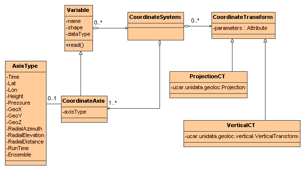
Coordinate Systems UML
For an overview, see: CDM Object Model. The Coordinate Axes for a Variable must use a subset of the Variables's dimensions.
A Transform is defined by creating a Coordinate Transform Variable (see Example and Reference). The attributes of the Coordinate Transform Variable become the parameters of the transform. A variable is a Coordinate Transform Variable if one (or both) of these is true:
Any Variable can be a Coordinate Transform Variable, as it is just a container for attributes, i.e. the data values of the Variable are not used by the transform. It is common to use a vertical coordinate to be a Coordinate Transform Variable. Using a dummy variable (with no useful data in it) is also common. The example here are done with dummy variables.
The CF CoordSysBuilder will add the _CoordinateTransformType attribute upon recognizing a standard_name, so adding that is optional if you are using CF Conventions. CF also requires that you use the vertical coordinate as the Coordinate Transform Variable, so that the transform will be added to any Coordinate System that uses that vertical coordinate. The CF CoordSysBuilder will thus add the _CoordinateAxes = "vertCoordName" attribute to indicate this.
A one-dimensional variable with monotonic values can act as a coordinate variable for its dimension, even when it doesnt have the same name as the dimension. To indicate this, add an attribute to the variable called _CoordinateAliasForDimension, whose value must be the name of its single dimension. A dimension may have multiple coordinate variables in this way, for example if the data is a trajectory.
   double valtime(record);
     :long_name = "valid time";
     :units = "hours since 1992-1-1";

  :_CoordinateAliasForDimension = "record";
     :_CoordinateAxisType = "Time";
This attribute lists (in any order) names of Coordinate Axis Variables. When a Variable is listed in a _CoordinateAxes attribute, it is made into a CoordinateAxis.
The attribute value must be a space-separated list of names of Coordinate Axis Variables in the same dataset:
_CoordinateAxes = "time lev lat lon";
This attribute is used on a Coordinate Axis variable to specify that it is a space or time coordinate, such as lat, lon, altitude or time. Currently the valid values are Lat, Lon, Height, Pressure, Time, GeoX, GeoY, GeoZ, RadialElevation, RadialAzimuth, or RadialDistance. This is the preferred way to make a Variable into a CoordinateAxis (the other way is to list the variable in a _CoordinateAxes attribute).
The attribute value must be one of the valid Axis Types, for example:
_CoordinateAxisType = "Lat";
This attribute is used on a Coordinate Transform variable to specify that the Transform applies to any Coordinate System with the specified list of Axis types.
The attribute value must be a list of the valid Axis types (see ucar.nc2.dataset.AxisType):
_CoordinateAxisTypes = "GeoZ Time";
When many data Variables use the same Coordinate System it is convenient to factor out the information into one place. We create a dummy Variable which holds all of the information, called the Coordinate System Variable .The _CoordinateSystems attribute is used on a data Variable to point to its Coordinate System Variable(s). This is the only way to indicate multiple Coordinate Systems for the same data Variable.
The attribute value must be a space-separated list of names of Coordinate System Variables in the same dataset:
 _CoordinateSystems = "ProjectionCoordinateSystem LatLonCoordinateSystem";

  char ProjectionCoordinateSystem;
 ProjectionCoordinateSystem:_CoordinateAxes = "time depth_below_surface y x";
  ProjectionCoordinateSystem:_CoordinateTransforms = "Lambert_Conformal_Projection";
This is a way to assign explicit Coordinate System to a set of variables, without having to name each variable. The value of the attribute is a list of dimensions. A data variable that does not have an explicit _CoordinateSystem or CoordinateAxes attribute will be assigned this CoordinateSystem, if it contains exactly the listed dimensions.
  <variable name="coordSysVar4D" type="int" shape="">
  <attribute name="_CoordinateAxes" value="x y zpos time"/>
  <attribute name="_CoordinateTransforms" value="zpos"/>
  <attribute name="_CoordinateSystemFor" value="xpos ypos zpos time"/>
  </variable>
  <variable name="coordSysVar3D" type="int" shape="">
  <attribute name="_CoordinateAxes" value="x y time"/>
  <attribute name="_CoordinateSystemFor" value="xpos ypos time"/>
  </variable>
The _CoordinateTransforms attribute is used only on Coordinate System Variables and is used to indicate how to transform the Coordinate System to a Reference Coordinate System. A Reference Coordinate System is one that uses Latitude, Longitude for the horizontal axes, and Height or Pressure for the vertical axes. To hold the transform information, create a dummy Variable called the Coordinate Transform Variable. This Coordinate Transform variable always has a name that identifies the transform, and any attributes needed for the transformation.
The attribute value must be a space-separated list of names of Coordinate Transform Variables in the same dataset.
 _CoordinateTransforms = "LambertProjection HybridSigmaVerticalTransform";

  char LambertProjection;
 LambertProjection:transform_name = "lambert_conformal_conic";
 LambertProjection:standard_parallel = 25.0;

  LambertProjection:longitude_of_central_meridian = 265.0;
 LambertProjection:latitude_of_projection_origin = 25.0;
This is a general mechanism for any transformation a file writer wants to define. The nj22 library has a set of
transforms that it recognizes, mostly based on the CF-1 conventions. Attributes should be
String, integer, or double valued.
This attribute is used to unambiguously indicate that a variable is a Coordinate Transform Variable (the other way is to list the variable in a _CoordinateTransforms attribute).
The attribute value must be one of the valid Transform types (see ucar.nc2.dataset.TransformType) Currently the valid values are Projection or Vertical.
_CoordinateTransformType = "Projection";
Only used for vertical coordinate axes to disambiguate direction up or down of increasing coordinate values.
The attribute value must equal "up" or "down".
_CoordinateZisPositive = "down";
May have attributes:
A Variable is made into a Coordinate Axis if one of these is true:
A Variable is a coordinate variable if it is one dimensional and one of these is true:
May have attributes:
A variable is a Coordinate System Variable if one of these is true:
May have attributes:
A variable is a Coordinate Transform Variable if one of these is true:
May have attributes:
You should use one or the other. If both are present, _CoordinateSystems is used.
A Data Variable is assigned one or more Coordinate Systems in the following way:
(see ucar.nc2.constants.AxisType)
| AxisType | description | order |
|---|---|---|
| RunTime | model run time | 0 |
| Ensemble | model ensemble | 1 |
| Time | valid time | 2 |
| GeoZ | vertical coordinate | 3 |
| Height | vertical height, convertible to meters | 3 |
| Pressure | vertical pressure, converrtible to hPa | 3 |
| GeoY | projection y coordinate | 4 |
| Lat | geodesic latitude | 4 |
| GeoX | projection x coordinate | 5 |
| Lon | geodesic longitude | 5 |
| RadialAzimuth | polar azimuth | 6 |
| RadialDistance | polar distance | 7 |
| RadialElevation | polar elevation | 8 |
 This document last updated on Jan 2015