


 Unidata's Integrated Data Viewer > Getting Started

2.8 Globe Display
The illustration below shows an IDV Globe Display of
GFS numerical weather prediction model output of
mean sea level pressure (as color-shaded image and contour lines)
and 50 m/s wind speed isosurfaces showing the jet streams.
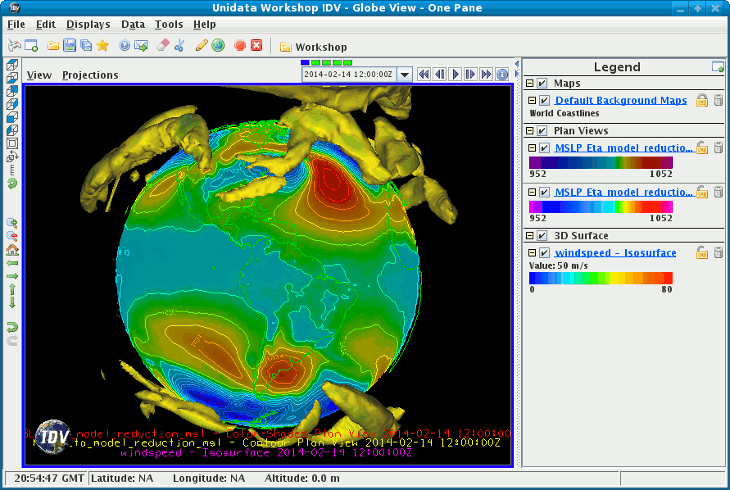 Image 1: Globe Display
To create a Globe View window, use the
menu. Uncheck the menu to turn
off the box in the display.
This section describes how to make plots of global satellite imagery on the
Globe display.
The set of steps include:
2.8.0 Choosing Global Satellite Imagery
After starting the Globe version of the IDV, select the
Image Chooser in the
Dashboard.
- Connect to the adde.ucar.edu server using
GLOBAL
dataset.
- From the
Image Data Type selector, choose the
Global Thermal IR composite images type.
- Click the
Add Source button to load the data source.
2.8.1 Displaying the data
Once the data source has been selected, from the Field Selector
you can create the display by doing the following:
- Select the "Global Thermal IR composite images" data source
in the
Data Sources panel.
- Select the "Band: 1" field in the
Fields panel.
- Select "Image Display" in the
Displays panel.
- Click the
Create Display button to create
the display.
2.8.2 Using the display
When the data are displayed, the default view will be from the
center of the image (0N, 0E). You can move the display using the standard IDV
zoom, pan and rotate functions.
For this exercise try the following:
- Use the menu to change the
viewpoint to an are of interest.
- Start the image animation using the
Animation Widget.
- Use the menu or the Viewpoint Toolbar to
set the view to the Western Hemisphere.
- Use the menu. Check
this on to spin the globe along the vertical axis. You can right click
on the Viewpoint Toolbar's Auto-rotate button to change the speed of
rotation.
- Click anywhere in the view to stop the rotation.
Any suitable data with navigation information (latitude, longitude, and
altitude) that the IDV can handle can be plotted on the globe
display. Review the section on
Plots from Gridded Data.
Unidata's Integrated Data Viewer > Getting Started